
Ottawa O-Train map
The eight OC Transpo lines and their 25 stations on one map, also as a PDF
The network map
 Enlarge
Train map as a PDF
Vector and sharp at any size, even printed at A3.
What the map shows
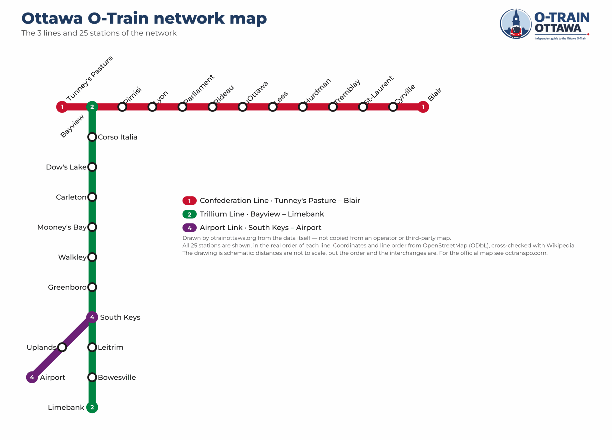
The map shows all three lines — which stations they serve, the order they come in, the colour of each line and where it runs. The coordinates of the 25 stations come from open data, and that is what underpins it.
What it shows first is how the lines cross at two points — Bayview (Line 1 and Line 2) and South Keys (Line 2 and the Line 4 airport shuttle): Line 1 runs east–west across the city and underground through downtown, Line 2 heads south to Limebank, and Line 4 branches off to the Airport.
| Line | Route | Stations | Length | Shared stations |
|---|---|---|---|---|
| 1 | Tunney's Pasture – Blair | 13 | 11,74 km | 1 |
| 2 | Bayview – Limebank | 11 | 18,47 km | 2 |
| 4 | South Keys – Airport | 3 | 3,89 km | 1 |
Every station by line
In order, terminus to terminus. Tap a station for its times and what is nearby.
Tunney's Pasture – Blair
13 stations · 11,7 km · 22 minutes end to end
Bayview – Limebank
11 stations · 18,5 km · 35 minutes end to end
South Keys – Airport
3 stations · 3,9 km · 7 minutes end to end
Frequently asked questions about the train map
Yes. The PDF above is vector: it stays sharp at any size, even printed at A3.
The map and the data underneath are credited on the sources and licences page, which says how you may reuse them.
Because the network reaches across the city: 18 of the 25 stations are outside downtown — south along Line 2 to Limebank and out to the Airport on Line 4.
At Bayview (Line 1 ↔ Line 2) and South Keys (Line 2 ↔ Line 4 airport shuttle), where the lines meet and you step across to the next train.